Andrew Grinberg: Add Your Voice as D.C. Updates its Transportation Plan
From Josh: This is the very first guest post by contributor Andrew Grinberg, a white neighbor on Trinidad Avenue who works on environmental policy for Clean Water Action and is in grad school at Georgetown for urban planning. I wrote a general article about participating in moveDC, but I wanted Andrew’s informed perspective for how we should respond in and around Trinidad. Look forward to more guest posts from Andrew and other neighbors and contact me if you want to write one!
Whether it’s the need for more frequent bus service or safe pedestrian and bike infrastructure, transportation issues are always a source of discussion here in ANC 5D. How we get around has huge significance right here and across the globe. In the US, transportation is the largest source of greenhouse gas emissions and is one of biggest expenses for most families. Traffic crashes kill more than 35,000 Americans every year and is one of the leading causes of death for minors.
The District Department of Transportation (DDOT) has just begun the process of updating moveDC, the long range transportation plan for the District. Adopted in 2014 as a follow up to the original 1997 Strategic Transportation plan for D.C., moveDC sets transportation goals such as what share of trips should be made by different modes (e.g. walking, biking, transit, driving etc), as well as the strategies, policies and metrics for reaching them. It also identifies corridors to prioritize transit, bike and freight movement.
DDOT has set up a number of ways to provide feedback, providing residents a chance to help set the course for what D.C.’s transportation system will look like in the coming years. DDOT is taking input until November 10 through the following ways:
- Take the survey: Let DDOT know what its priorities should be, such as which types of policies (such as safety) and which modes (transit, bike, pedestrian) to focus on.
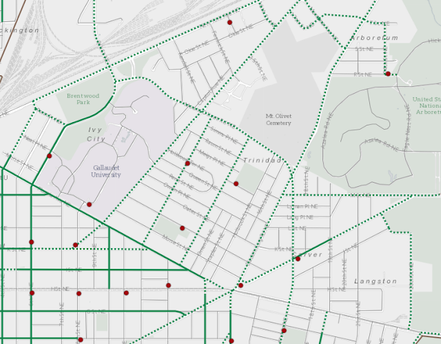
- Provide feedback on maps: These interactive maps allow residents to make specific suggestions, such as streets that should prioritize public transit with bus only lanes, where bike lanes should go (map above) and where trucks can drive.
- Call in to phone “office hours.” Info here. If you want to talk to someone instead this is for you.
As I consider what DDOT needs to know to make the transportation system work for me, my family and my neighbors, here is what I’m thinking about:

Photo courtesy of Andrew Grinberg and map from the Bicycle Priority Network. (The dotted green lines are proposed bike lanes and the solid green lines are existing lanes.)
- Neighbors — like you — know best about what is needed on our streets where we live. Is there a bus stop near you that should have a bench and shelter? Is there an intersection that needs a stop sign (Montello and Morse anyone?) or a street where cars regularly speed (Trinidad Ave)? Make sure you put these on the map!
- Right here in ANC 5D and in surrounding neighborhoods, we have a lot of major roads that are unsafe for biking and walking and where buses (or the streetcar) get stuck in traffic. We need improvements like better sidewalks, bus only lanes and protected bike lanes that address these issues. I am telling DDOT that we need bus/streetcar only lanes on Bladensburg Road, Florida Avenue, New York Avenue, Benning Road and H Street NE; and that we need protected bike lanes or trails on Mt Olivet Road, New York Avenue, West Virginia Avenue, Benning Road and H Street NE.
- There are also smaller streets where DDOT is considering adding bike lanes, such as on Trinidad Ave (in photo below) and Montello Ave — which would enable people to bike in either direction on these one way roads. There are “contraflow” bike lanes like this nearby, such as on G Street and I Street, which could work well here. Adding bike lanes and narrowing the driving lanes, would also slow down traffic on these streets — both notorious for speeding.

- About 17,000 people live here in ANC 5D (according to the 2018 American Community Survey 5-year estimate), and the population is projected to increase to more than 28,000 by 2045 (according to Metropolitan Washington Council of Governments here and here). About 5,000 people work here in 5D, and that is projected to nearly triple to over 14,000. This growth means we need to enable people to move without driving — otherwise we will be overrun with cars, traffic and pollution.
- 45.3% ANC 5D households don’t own a car — a much higher share than D.C. as a whole (36.7%). We need to make sure our neighbors who don’t drive have options for getting to work, school and anywhere they need to go.
- 24.9% of ANC 5D residents who are 16 and older and work, take the bus to commute — much higher than the rest of D.C. (13.7%). Since most of our ANC is not within walking distance of a Metro station, having a great bus system is crucial for us to access jobs and essential services.
Photo courtesy of Andrew Grinberg and map from the Bicycle Priority Network. (The dotted green lines are proposed bike lanes and the solid green lines are existing lanes.)


Thanks. Took survey and commented on maps. I am curious what your perspective is on the proposed freight priority for W VA Ave. Seems to me like Bladensburg would be sufficient, at least south of Olivet.
ReplyDeleteThanks for reading! I'm pretty agnostic on freight priority on these corridors. Bladensburg has more traffic capacity, but also more foot traffic south of Mt Olivet. Maybe having both as options helps spread out the intensity of truck traffic? Curious as to what others think about this too! What's clear to me is that both need major safety improvements for pedestrians, people on bikes and drivers - regardless of freight.
Delete